.png?width=287&height=287&name=social%20post%204%20(5).png)

.png?width=287&height=287&name=social%20post%201%20(1).png)

MOBILITY
Take photos on-site
Need to provide supporting evidence or additional context to show what's happening on-site. Take photos on the go using your device and upload them to Sablono in moments.
ACCESSIBILITY
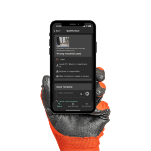
Attach photos directly to your activities
Organise your data for convenience and accessibility. Easily attach every photo to the specific activity or QA item that it corresponds to in the Sablono app.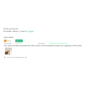
GEO-LOCATION
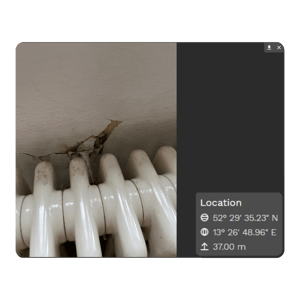
Get geo-location details for each photo
Need additional evidence to comply with building regulations? All photos are geo-tagged which means you can easily identify the specific location where the image was originally taken.
THE RESULTS ARE CLEAR
Why use Photo Documentation
Without Sablono
Struggle to add photographic evidence on the goPhotographic evidence poorly organised
Difficulty providing geo-location
With Sablono
Easily attach photographic evidence on the goAttach photos directly to activities or quality checklist items
All photos include geo-location
Photo documentation for all use cases
See all use cases
Façade package
Accurately track façade panels, manage and store quality data for each panel in one place and finish in record time.

Fit-out package
Simplify handovers during fit-out, understand how your package is progressing in real-time and keep all your trades on the same page.

Remediation works
Easily coordinate all remedial work in one place, plan your workflows down to the smallest detail, and keep a digital record of the entire remediation process.

Piling package
Plan your piling package down to the smallest detail, adapt to unforeseen ground conditions quickly and work faster.

Firestopping
Streamline your firestopping workflows, store all your documentation in one place and access this at any time as evidence of compliance.

Structural package
Manage and coordinate all aspects of your structural package. Plan your workflows down to the smallest detail and keep a clear record of compliance.

Facade and Balcony production
Efficiently produce and manage façades and balconies with streamlined processes and meticulous quality control using our innovative production tracking system.

Bathroom production
Optimize your bathroom production process with precise tracking, comprehensive quality management, and accelerated project completion using our specialized system.

Kitchen production
Utilize our advanced system to efficiently track kitchen components, streamline quality management, and expedite project completion for unparalleled results.

POD installation
Enhance your prefabricated pod installation process with precise tracking, centralized quality management, and accelerated project timelines using our innovative solution.

Solar installation
Maximize efficiency and quality assurance in solar panel installations by utilizing our comprehensive tracking system to manage and store critical data, ensuring timely completion with optimal results.
Bring it all together
Photo Documentation is just the beginning. Use it with Sablono's other quality and compliance features to get more done with less. QA Checklists
Attach QA checklists to workflow activities to ensure that all required quality data is captured in one go.
Read More
QA Checklists
Attach QA checklists to workflow activities to ensure that all required quality data is captured in one go.
Read More
 Activity Sign-off
Management is automatically notified when activities are marked as complete so all work can be reviewed before sign-off.
Activity Sign-off
Management is automatically notified when activities are marked as complete so all work can be reviewed before sign-off.
 Issue Sign-off
Management receives automatic notifications as soon as issues are flagged and has final sign-off before the issue is marked as resolved.
Issue Sign-off
Management receives automatic notifications as soon as issues are flagged and has final sign-off before the issue is marked as resolved.
 Issue List & Reports
See all issues raised and export PDF reports to streamline their resolution or as evidence of quality and compliance standards being met.
Issue List & Reports
See all issues raised and export PDF reports to streamline their resolution or as evidence of quality and compliance standards being met.
 Issue Templates
Create reusable templates for issues which help you to standardise documented issues to streamline their resolution and ensure work always meets quality and compliance standards.
Issue Templates
Create reusable templates for issues which help you to standardise documented issues to streamline their resolution and ensure work always meets quality and compliance standards.
 Photo Documentation
Attach geo-tagged photos as evidence of quality and compliance standards being met.
Read More
Photo Documentation
Attach geo-tagged photos as evidence of quality and compliance standards being met.
Read More
 Quality Audit Trail
Create a fully accountable, connected digital audit trail of all quality-related data.
Quality Audit Trail
Create a fully accountable, connected digital audit trail of all quality-related data.